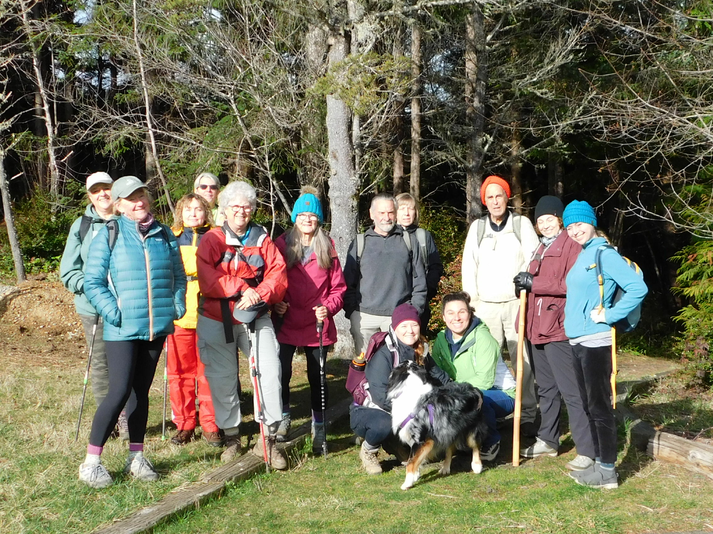
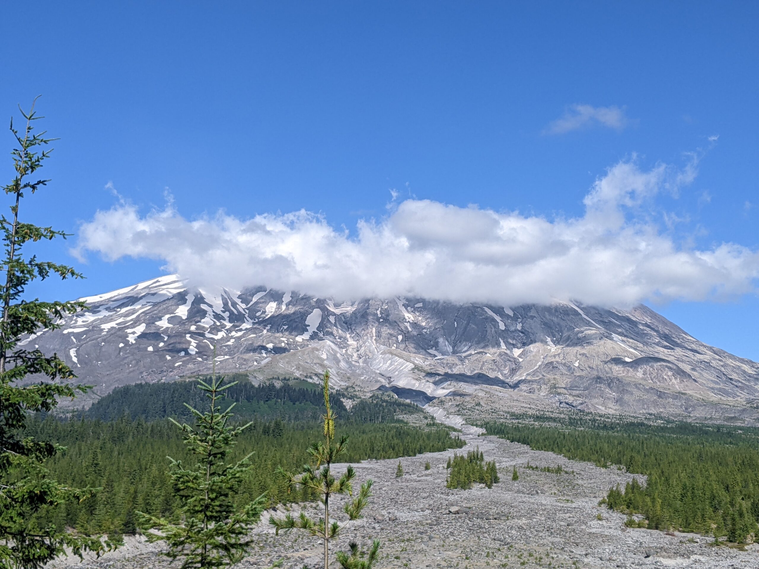
Cow Creek Trail – November 11, 2023

Hike Coordinator: Terry Andreucci

Umpqua National Forest – Cow Creek National Recreation Trail #1424 (usda.gov)
This National Recreation Trail follows Cow Creek through a dense stand of Douglas-fir and Western Hemlock for approximately 4 miles. Giant old growth, lush glades of moss and ferns—including maidenhair and swordfern—and brilliant fall colors are features of this part of the trail. With five creek crossings up to two feet deep, hikers cross by using stable, downed logs to use as bridges.

Pictures below by Rheo Wheeler

Rogue River: Marial to Paradise Lodge – May 27, 2023

Hike Coordinator: Edwin Case

On this pleasant spring day Edwin led over a dozen hikers down the Rogue River Trail, starting from Marial Lodge. The destination was Paradise Lodge several miles downriver. Although the drive to get to the trailhead at Marial is not easy, this portion of the Rogue River Trail is quite spectacular and well worth the effort.

Since Edwin is more of a hiker and not a writer, tales and specific events of this hike may remain a mystery. But with the great turnout for this hike, the odds are good that many memorable moments were made. And if anything happened this day that is worth repeating, it’s certain we’ll hear about it, so stay tuned…

Pictures below by Rheo Wheeler

Mt. Pisgah – May 13, 2023

Hike Coordinator: Missy Kroeker

Narration by Missy Kroeker

After such a long, wet winter, spring was here and a handful of eager hikers gathered in the courthouse parking lot to travel to Eugene and the Howard Buford Recreation Area. Also known as Mt. Pisgah for the “mountain” in the park. At the trailhead we met up with Bekah, her dog Bailey and my husband, son and granddaughter. I hadn’t hiked much this winter due to a variety of reasons and it felt good to be on the trail. Spring in Oregon is such a beautiful time of year. Everything is so green! The Mt. Pisgah trail did not disappoint.

I had led this same hike last year. We, again, started at the Southeastern trailhead and made a 7-ish mile loop through the park. It was a warm, clear day. Camas lilies and wild iris lined the approach to the summit. Is Mt. Pisgah getting steeper or am I getting older? I know it’s the later. As always, the views are inspiring. The snow covered Three Sisters to the north, Diamond Peak to the east and the lush farmland near the Williamette River to the south and west. We gathered for our group photos at the summit and said goodbye to my son and granddaughter, who needed to return home. The remainder of us continued on to Swing Hill for lunch. After lunch and some rest, we continued our loop back to the Southeastern trailhead.

It was an enjoyable warm Spring Day hiking with old and new friends. Even though Mt Pisgah is relatively close to home it felt like we got out away a bit. Spring is the time for hope. Hope for new things to come and hope of another great hiking season.

Pictures below by Missy Kroeker

Cape Mountain – April 15, 2023

Hike Coordinator: Lane Harris

Narration by Lane Harris

The Cape Mountain Trail system in the Siuslaw National Forest just north of Florence provides hikers and equestrians alike with a variety of options. Cape Mountain itself is not the destination, but the area around it is. With a multitude of intersections here and there, there are many different ways to hike this wooded place.

On this day, our group took the Princess Tasha trail to the Berry Creek trail, then the Nelson Ridge trail back to the trailhead. Although only a few miles from the Pacific Ocean, the dense forest here makes hikers feel like they’re a world away from any ocean. Only when you’re on top of Nelson Ridge can you see the ocean in the distance. It was here where we stopped and had lunch before continuing on.

Although there are no grand vistas, the solitude of this place is well worth the drive to the trailhead.

Pictures below by Lane Harris

Tahkenitch Dunes – April 1, 2023

Hike Coordinator: John Malone

Some foolish hikers decided to trek through the sands of Tahkenitch Dunes this April Fool’s Day. Ok, so maybe it wasn’t so foolish, as it was a gorgeous day for a hike on the coast! This club favorite has a little bit of everything, from lush forests to sandy dunes and of course, the beach. Always a crowd pleaser, the variety of terrain keeps hikers coming back for more.

Pictures below by Tami Morin

Rogue River Trail – March 18, 2023

Hike Coordinator: Terry Andreucci

Narration by Lane Harris

On this marvelous March day, Terry had at least a dozen hikers make their way to the trailhead near Graves Creek to hike the always-lovely Rogue River Trail from the boat ramp to Whiskey Creek and back. With a handful of man’s best friend tagging along, not a dull moment was had this day.

There was a chill in the air when the large group started, and right away we were traversing the small swollen creek that runs near the parking lot. Unbeknownst to us, this would be a small practice run for what lay further ahead on the trail…

This was one of those days where everyone had their rain jackets on, as there was that feeling in the air as if it may rain at any moment. But just like when someone puts a near-empty milk carton back in the fridge, barely a drop was to be had. We experienced some grey skies and some sun. Kinda perfect weather, really. Cool, but a little sun to keep you warm when not hiking.

As we made our way down the trail, there were several creeks which required some clever negotiating. The recent rains and snow had made all the local creeks absolutely engorged with water! Looking across the river, one could make out many waterfalls cascading off the hillsides, with snow still present on the highest part of the hills.

At one point, we all had to make a short scramble off below the trail to avoid the rushing water that had pretty much inundated our path. To attempt walking down that watery way would have been quite risky, with the slippery footing underneath surely having the last laugh. Thankfully, no hikers were smitten by the water gods this day.

Normally, all the wildflowers are just bursting with color this time of year. But due to the long, late winter we’ve had, the flowers were just starting to do their thang. Give this place another a few weeks or so and the real show should be in full swing!

After successfully crossing multiple creeks running across the trail, we eventually reached Whiskey Creek cabin. As the group did a self-guided tour of this historical site, I was doing a little looking around too, and found a geocache, totally unintentionally! It was an ammo box locked to an old cable just uphill from the cabin. With curiosity, I took a quick look inside, then placed it back where I found it. (TIP: If you ever stumble upon a geocache and are not actually participating in the sport, please be courteous and leave it where you found it so others who are looking for it can find it) I always thought geocaching would be a neat thing to do, but just haven’t made the effort. You need a GPS to participate, but I typically use mine to prevent from getting misplaced in the woods!

After having a late lunch along the edge of Whiskey Creek, the group made its way back upriver. We were all spread out along the trail, just enjoying the magnificence solitude and the grandeur that is the wild Rogue River. Although we ran into quite a few other hikers this day, it just reaffirms that this place is worthy of visiting, and visiting often, as evidenced by the amount of people who walk these banks of the Rogue River Trail.

Pictures below by Lane Harris

Cooper Creek Reservoir – March 4, 2023

(Formerly known as Cape Mountain)

Hike Coordinator: Lane Harris

Narration by Lane Harris

“If the plan doesn’t work, change the plan but not the goal.”

~ Anonymous

I imagine this anonymous guy or girl must’ve had a big hike planned and had to change it at the last moment. Ok, so I guess that quote could fit almost any given situation when a plan goes awry. Regardless, it certainly applied to today’s planned hike to Cape Mountain near the coastal town of Florence, although it more or less did not come as a big surprise.

I had been watching the weather forecast all week, keeping a keen eye on Saturday. Depending on which tv channel I watched, which app I looked at on my phone, or which website I saw, they all seemed to be anticipating less than desirable conditions for hike day. Well, ain’t that a kick in the ol’ hiking pants! As the day drew nearer it was appearing, at least to me, that the gloomy forecast had lightened up a bit, and maybe it wasn’t gonna be as bad as they said it was going to be. (BTW, who are “they” anyway?…)

I was somewhat optimistic as I pulled into the parking lot at 7:45am, imagining that I would have a good little group who were eager to be adventurous and brave a little rain, and poo-poo all those so-called weather forecasters. So far it was just John and Tracy who had arrived and were ready to go. No problem, we had 15 minutes for the other hikers to arrive. Ah, here comes one now. It was Edwin. Ok, so that makes four of us. Tracy then mentioned that she was not up to driving 5 hours (roundtrip) to hike in the cold. And so began our discussion about the weather, the cold, the possible snow, rain, etc. I said, “Perhaps we should wait to make any decisions until everyone else shows up.”

It was now 8:05 and everyone else did not show up. The four of us were the “everyone else.” Oh, wait here comes another…. oh, never mind, it’s just a random car passing through the parking lot. We discussed our local hiking options, and finally settled on Cooper Creek Reservoir just east of Sutherlin. Edwin, who had previously stated that if we changed the hike that he would probably just go home, did just that. I can’t say I blame him, as he’s been there done that when it comes to all the local hikes. I sent a text to Rebekah, an interested hiker on the coast, informing her that we were not hiking at Cape Mountain today. She was going to meet us at the trailhead, and I didn’t want her waiting for us unnecessarily. So, it was just the three of us now, and with that, we climbed into my truck and sped off. We had just changed the plan but not the goal… to go hiking!

Once we were at Cooper Creek, I decided I better call Tom with the South Coast Striders. His group was also planning on meeting us at the trailhead near Cape Mountain, and I was envisioning his gang of angry coastal hikers waiting around in the rain for us mild-mannered inlanders to show up. To my relief, however, he informed me that he had only one person that was interested, so they pretty much bowed out of the whole thing. I love it when a plan doesn’t come together!

John, Tracy and I started the 6.2-mile hike around the reservoir under nasty skies. The rain wasn’t heavy, but it was cold, and even turned to wet snow for a while. There was even a bitter wind, acting all windy and such. But once we got under the canopy of the trees, it wasn’t so bad. And after maybe 30 minutes of hiking, the weather actually got better! The wind and rain ceased, and it was quite pleasant. Yes, it was still 37 degrees, but compared to what the forecast was, we accepted this as a gift from the hiking gods.

Our hike was rather uneventful, which was fine with us. Lots of waterfowl were spotted, fish were jumping, and I even saw a rabbit! Parts of the trail were a bit muddy, but that didn’t bother us at all. We were just happy to be hiking and not being drenched in cold H2O. That’s never really all that much fun, trust me, even on a Richard hike. Unsurprisingly, we did not see any other hikers this day.

Upon returning to Roseburg, I checked my phone. I had received a text back from Rebekah on the coast. Her response to my cancellation was “That’s ok, this was a mile out from the trailhead anyway.” Attached was a picture (the last one in the slideshow below) of a snow-covered road with several trees across it, blocking any would-be hikers from reaching the trailhead near Cape Mountain. 😲

Thus, our smart decision to change plans but not the goal was validated with that photo. I’ll say it again, I love it when a plan doesn’t come together!

More pictures on Lane Harris’ Flickr page

Pictures below by Lane Harris

Heceta Head – February 18, 2023

Hike Coordinator: Penny Groth

Narration by Penny Groth

Fifteen eager hikers gathered on a cold (but dry!) morning at the courthouse. Destination: Heceta Head lighthouse and trail! Upon our arrival at the lighthouse, we were joined by 10 – 15 Striders (Coos Bay hiking club). So, well, there was a mob of us (a friendly one)!!

Leaving the parking lot, we journeyed up the half mile wooded path, passing the picturesque caretakers house, then on to the lighthouse.  Then up, up along the trail, including a lot of fairly steep stairs (bun-burners for sure – ha)! Alas … the reward at the top – an awesome view of the ocean.

Continuing through a beautiful stand of Hemlock, we crossed Hwy 101 and hopped onto the Valley Trail: peaceful, lush green forest, wetlands, ponds and creek runoff. At Washburn State Park, we crossed back over Hwy 101. Just in time for lunch on the beach. Oh my, what a pretty February day! Sun AND no wind. We found the perfect log to perch … we resembled a lineup of turtles on a log in a pond. But nope, it was us basking in the sunshine!

We toodled along the beach, then up the Hobbit Trail (no hobbits sighted) where we intersected with our beginning trail. It was a little sunnier on our return trek, so that awesome view of the ocean on our way up – well might have been a bit more awesome!!

We did a tad more than 7 miles, 7.2 to be exact. With lots of up and down, this trail offers a variety of scenery for the eyes and soul. Rest assured, it’s a good one!

Be sure to subscribe to our YouTube channel!

Pictures below by Penny Groth

South Slough – February 4, 2023

Hike Coordinator: Rheo Wheeler

Narration by Rheo Wheeler

With a nicer weather forecast for our hike day, we had a good turnout for our trek through the South Slough Estuary. Eleven F.O.U. members plus 3 from the South Coast Striders out of Coos Bay joined up at the information center.

With no information on the Slough’s website, we were surprised to see the parking lot nearly full, and the bathrooms were under construction. They had a class in chainsaw handling, which drew in a few people. Most important though, they had brought in port-a-potties, since the bathrooms were out of commission.

We headed downhill through the forest to the water area where there was an 8+ foot tide covering all the mudflats. This is a very easy 3+ mile hike over boardwalks and forest trail, with the hardest part at the end where it’s uphill back to the start.

After our leisurely stroll at the slough, the group split up, with some opting for clam chowder in Charleston, others heading to the beach at Seven Devil’s, and others just wanting to head home. It was a very pleasant day in a beautiful area.

Pictures below by Rheo Wheeler

Dellenback Dunes – January 21, 2023

Hike Coordinator: John Malone

Narration: Rheo Wheeler

Dellenback Dunes was a 6+ mile hike in the wind and rain. Not ideal conditions when you have a spectacular destination, worse when it’s a slog out and back with no beach time. King tides of 8+ feet kept us in the dunes for this test of our raingear.

We had a great turnout of 18 hikers and 4 dogs for this adventure and hopefully they won’t hold this against us and come back when conditions are better. Yardangs (wind sculpted sands) were not as prevalent as earlier in the week with rain obstructing long range views as we headed north along the deflation plane.

Everyone had a good attitude, despite our inclement weather: Welcome to Oregon in winter.

Pictures below by Rheo Wheeler

Scroll Up