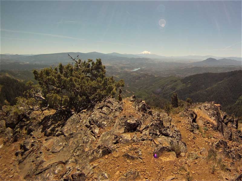
Jack Ash Trail – June 30, 2018

Hike Coordinator – Lane Harris

Despite a long drive and one flat tire, 11 people enjoyed this one-way 6 mile mostly downhill hike on the newly developed Jack-Ash trail near Jacksonville and Ashland, OR (thus, the Jack-Ash name, which surely conjures up snickers from those of us still in the 2nd grade, mental-wise). The weather was a tad on the warm side (low 80’s) but it was tolerable, as higher elevations tend to provide cool afternoon breezes.

With Lane Harris leading the group, hikers headed out around noon, beginning at the Anderson Ridge trailhead near Anderson Butte. The trail was gentle and meandered along grassy fields covered with wild flowers still abloom on this final day in June. After a very gradual 1.5 mile sidehill climb underneath the butte, with stunning views to the west and southwest, everyone took a shady break underneath some trees to enjoy lunch. At this point, the trail was no longer going up, and as they say, “It’s all downhill from here!”

After a very scenic stroll through more open forest, flora and fauna, the trail spit us out at the Greenstone trailhead and onto a gravel road. The group accepted this 1 mile road hike as an interlude and an opportunity to chit chat with one another, as that sort of thing is a bit difficult when walking single file on a trail.

We soon rejoined the trail at the Griffin Gap trailhead and commenced our downhill march. The expansive views here were a bit sparser, but the trail was still throwing great scenery at us, with plenty of firs and pines as the staple of this portion of the hike. With occasional views to the valley below, the trail dropped quickly, with madrone trees and manzanita bushes starting to populate this part of the dry hillside.

Soon, the road which we had parked one vehicle at came into view. As the trail did multiple switchbacks across the hill, hikers could see the destination, but the trail kept teasing us, as if the we were in a funhouse with mirrors! Just when you thought you were taking that last turn to the end, there was another switchback! A bit frustrating, to say the least, in this afternoon heat. But eventually, we all exited the path at the Grub Gulch trailhead without incident.
Best of all, there are now 11 new bona fide “Jack-Asher’s”.

Pictures by Lane Harris

Cowhorn Mountain – June 16, 2018

Hike Coordinator – Edwin Case

Only four hikers showed up for this hike. Lindsey, Brad, Larry, and I arrived at the trailhead near Tipanogas Lake Campground at 10:30. We hiked along the north side of Lake Tipanogas then up and around the valley, walking through forest and past ponds up to the summit of Cowhorn Mountain. There were still a few patches of snow hiding the trail here and there but we found the trail easy to follow despite the snow drifts. This was a very different story just a week before when Richard and I pre-hiked this route on a hike that tested our route-finding skills. We are happy to report that all four of us made it to the top of Cowhorn Mountain to soak in the panoramic views from Crater Lake rim to the Three Sisters.

Instead of going back the way we came, we decided to make this a loop hike by way of taking the trail to Indigo Lake, making this approximately an 11.2 mile hike. It was a long day as we didn’t arrive back at the trailhead until 5pm. Although a 50% chance of rain was predicted, we only saw cloudy skies – however it was pretty cold at the summit.

Enjoy the pictures and we’ll see you next hike!

Pictures by Edwin Case

Boccard Point – June 2, 2018

Hike Coordinator – Brad Bishop
 

Five hardy hikers showed up on a beautiful late spring day for the PCT to Boccard Point hike on June 2nd. Jane, Diane, John and myself left Roseburg and met our newest member, Chelsea, at the Soda Mountain trailhead. The weather forecast the temperature to reach 90 degrees, but we pushed on, undaunted with the physical demands this 10 mile trek may require of us mere mortal souls. We were on a mission to see Oregon’s natural beauty and spiritual fulfillment on this day. As we started the trail a cool breeze whispered it’s encouragement to us to push on and be not afraid of what we may perceive as a daunting task. Through out most of the hike we were shielded by the nurturing forest that seemed to say, “Be one with nature and find the sacred path”…we pressed on. Diane and Jane broke off to find the elusive path to little Pilot Peak and we would not see them until much later. As we turned off the PCT towards Boccard Point a feeling of anticipation enveloped us. Would the reward be worth the sacrifice as the forest now retreated and left us open to the steady solar energy  surrounding us? The trail, though sometimes hard to follow, led us through a myriad of landscapes to a rocky outcropping that gave us magnificent views of of Southern Oregon and California’s Shasta Valley. It was definitely worth it. On the way back we cursed the comfortable downhill we had traversed before and had now become a steady uphill battle of lungs and legs verses gravity, thank goodness the forest was there to shade our bodies and keep us going. We met up with Diane and Jane  a couple of miles from the trail head and rejoiced at the splendor that is being able to walk in the Garden of Eden that we call Oregon in the spring time.   

Pictures by Brad Bishop

Scroll Up