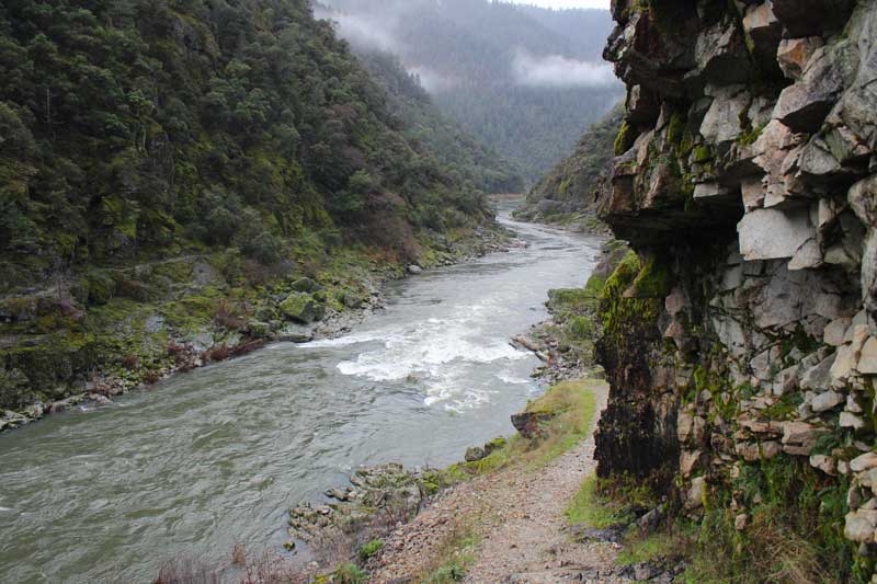
Rogue River Graves Creek to Whisky Creek Cabin – January 27, 2018

Hike Coordinator – Brad Bishop

Two carloads of hearty hikers braved the cold, the Rogue and a rookie hike leader on our Graves Creek to Whiskey Creek adventure on January 27. Would it snow? Would anyone be swept into the Rogue by the waterfalls we had to cross? Does Brad know where the heck he’s going? No, No and kinda.

The weather was threatening to rain, but actually did so very little. We even enjoyed an occasional burst of sunlight as we hiked our way along the precarious ridge of the gorge. With the recent rains many of the small waterfalls crossing the trail looked dangerous enough to sweep the unsuspecting into the Wild Rogue, but all of us managed to make it through with guidance from the veteran hikers, some of whom were even pointing out landmarks such as the high-water mark of a 1960’s flood.

Through tree cover and rock outcroppings we made our way to the old Miners Cabin for a cold but dry lunch. There stories of past expeditions on the Wild Rogue were told and a consensus view that if you tried to sleep inside the electric anti-bear food fence, that you would be demoted back to Bushwhacker. 

After the brief respite we headed back to our starting point of Graves Creek with a sense of accomplishment, that, with our toughness, perseverance and determination we could overcome anything nature had to throw at us. Until the trail-runners passed us up, then we did’t feel so tough anymore  

Pictures by Richard O’Neill

Cape Blanco – January 13, 2018

Hike Coordinator – Lane Harris

On this superbly sunny day in January, and the first club hike of 2018, Lane led over 30 (maybe 40?…) eager hikers on a hike through the inland forests and sandy beaches of Cape Blanco. Several members of the South Coast Striders hiking club made up part of the thundering horde as we all set out along the Sixes River and straight up grassy slopes with the Cape Blanco lighthouse as our first destination.

With many previous hikes at Cape Blanco under his belt, Richard took the lead, ensuring the speedy hikers did not get misplaced, what with all the many trail junctions along the way. Lane stayed at the rear of the pack, assisting some newbie hikers who had physical limitations, and who were relatively new to this hiking thing. With his encouragement, they all ultimately made it up the first steep climb, which was shortly followed by “this-was-totally-worth-it” type comments upon reaching the first viewpoint of the lighthouse and the expansive ocean beyond.

The day was glorious as hikers basked in the sun and enjoyed lunch next to the historic lighthouse atop the cape. To the north, hikers took delight in an epic vista of the Sixes River and Blacklock Point, with all manner of islands dotting a bay of blue water. To the south, a long beach arced towards Port Orford with Needle Rock being a prominent feature below the cape. A thin layer of mist clouded up the beach while it was nothing but blue skies atop the cape.

By the time everyone had finished lunch, the temperature had warmed up enough that most of us had to shed a layer or two and continued the hike with either a long or short sleeved t-shirt. At this point, light jackets were optional. With the wind light, and the sun warm, this had to be one of the most fabulous days, weather-wise, that any of us had experienced on the Oregon coast.

With the exception a few hikers, who decided to make this a 4’sh mile hike by taking the northern beach trek back to the trailhead, the rest of us continued south toward the campground. After an easy ramble along and atop the windblown bluffs, the trail entered a thick coastal forest. Once we went past the campground, a short road walk dropped us down to beach level about a mile south of Cape Blanco. To the south rose the forested mound of Humbug Mountain with the rest of the coast disappearing into the misty haze.

From here on in, it would be pretty much a beach walk back to the car, although the beach walk was bisected by the formidable redoubt of Cape Blanco. Large driftwood logs lined the beach below the yellow (gorse was blooming on the hillsides) cliffs. At the end of the beach, Needle Rock loomed, seemingly trying to pop the blue sky balloon above. We all sat and rested for a bit, gathering our strength for the steep climb to the top of the cape. There is no official trail, just a steep, muddy goat path that goes straight up! Upon reaching the intersection near the lighthouse, another steep and muddy path took us off the cape and down to the beach on the north side. A mile later, we arrived at the Sixes River. From here, we followed a sand-laden trail inland for about ½ mile back to the trailhead.

This was quite an unforgettable day that our large group experienced. 2018 was off to a great start with this wonderfully scenic hike along the beautiful southern Oregon coast.

Pictures by Richard O’Neill

Scroll Up