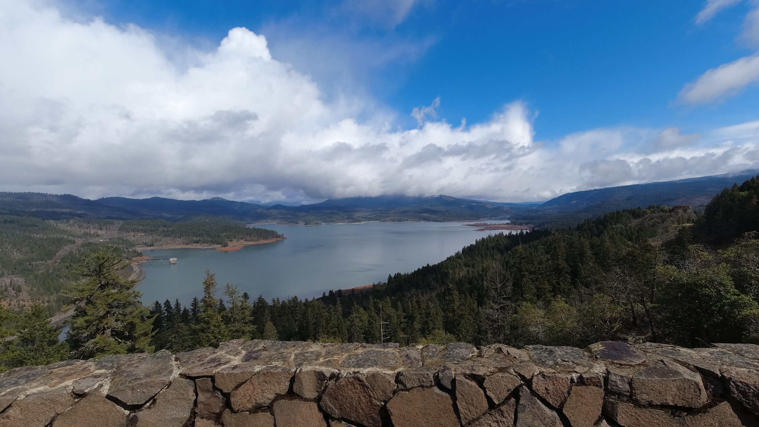
Lost Creek Lake: Viewpoint Mike Trail – March 20, 2021

Hike Coordinator: Lane Harris

Narration by Lane Harris

Lost Creek Lake sits smack dab between Medford and Crater Lake on Hwy 62. Amazingly though, when you mention Lost Creek Lake to most people, they have no idea where it is. At the size of 3,400 acres, this large body of water is popular for summertime watersports such as boating, skiing, wake boarding, tubing, and jet-skiing. And in the springtime, it’s a fine place to hike the surrounding trails.

On this day, the weather seemed to want to play with us, being a bit tempestuous at times on the drive south on I-5 from Roseburg. Was it going to rain? Was it going to be sunny? Or somewhere in between?…

When we arrived at the trailhead, we felt fairly confident the weather gods would be kind to us as we laced up our hiking boots. After I gave a quick brief, we walked across the road to the trail’s beginning and started the 1000 ft. climb.

This was my first hike with the club using my very first action camera, you know, like a GoPro. I told everyone not to worry about what they said as I filmed, as it would all be dubbed over with music. While that remark was received with some skepticism, no one seemed to mind the nerd with a small camera attached to the end of what appeared to be the world’s lamest trekking pole. I just held it high and proud, like a little kid who was nominated to be the flag-bearer in some sort of small-town parade, hoping that the big kids wouldn’t make fun of him later.

I knew that getting images of hikers in action would be the core of any hiking video I created. So how hard could it be? I mean, I hike with them, right? Well, as I was concentrating on getting some decent footage of our hike, I realized that every time I paused to film, the group would swiftly get further away from me. I would walk briskly to catch up, get some footage, and then rush to catch up again. Apparently, this would be my modus operandi for the rest of the hike. And quite possibly, for every hike from here on out if I was to capture the sleek, gazelle-like creatures, otherwise known as fast hikers!

While my legs ached and my shins screamed in pain, I contemplated the prudency of my decision in pursuing the fine art of producing amateur hiking documentaries. I think I can add “fast hikers” to what W. C. Fields famously said when he said “Never work with children or animals”. I mean, literally, what a pain!

I was fortunate enough to have some other not-too-fast hikers with me this day, so they were the lucky (?) stars that appear early on in my video production. Whether they were searching for the spotlight or just the mere reluctant recipients of being caught on video, I nonetheless appreciate their willing, or unwilling, participation.

Although the hike up to Viewpoint Mike gains 1000 ft from the trailhead, there are flat parts of the trail that one can just cruise and enjoy. Nestled between Hwy 62 and some private property, it at times feels like you haven’t gone very far off the beaten path. But when you turn a corner and disappear into thickets of pine and manzanita, you forget about how close to civilization you are. And speaking of manzanita, that was the crux of several puns we came up with on the trail. Example: What’s a manzanita on a hot, dusty trail? Water! (If you don’t get it, you’ve never hiked with me and Richard!)

At one point, a road walk is involved, but like my career in comedy, it’s very short-lived. The trail then begins the climb up, up, and up amongst a proper forest setting. This well-maintained trail is easy to walk on, and has one purpose: to get you to the top. The scenery on the way up may be unremarkable, but it’s certainly not disappointing either.

Within a quarter mile from the top, the trees give way to open, rocky terrain, giving hikers some hope that there must be something special up ahead. Upon reaching the top, we were rewarded with an amazing view of Lost Creek Lake to the north! And to the south? Just some stupid trees. But to the north, that’s where you look. And on this day, a rainbow had appeared as a bonus! We sat down and partook in the ritual which is lunch, and just generally had a swell time admiring the views. After our fill of sandwiches and rainbows, we promptly said goodbye to Mike and his viewpoint, and set off down the hill.

To the delight of my shins and legs, it was much easier keeping up with the gazelles heading downhill, as I filmed them prancing around in their natural habitat. Ok, so maybe the only prancing happening was me and my selfie-stick trying to get footage of our downhill escapades. (Is it just me, or does it sound wrong to use the word “selfie-stick” in ANY sentence?….)

As hikers spilled out onto the parking lot from the descent off of Mike’s quaint little viewpoint, we were thankful that the weather held and had provided us with another excellent day of hiking. And I, for one, am glad that no hikers were harmed during the filming of this hike.

Post-hike note: After the creation of my video, I must admit it came out pretty good! I won’t win any Oscars or Golden Globes, but at least I’ll always have my selfie-stick! (Again, that just sounds wrong…)

More pictures on Lane Harris’ Flickr page 

Pictures below by Lane Harris

Floras Lake & Blacklock Point- March 6, 2021

Hike Coordinator: Diane Rannow

Narration by Lane Harris

On a cool but pleasant day, Diane led a group of us from Floras Lake down the beach to a cliffside waterfall. Diane had already done the calculations to guarantee a low tide for this hike, thus ensuring that we had enough sand to walk on. The last thing you want is to have an encroaching ocean ruin your beach hiking plans! With Diane in the lead, the rest of us followed. Myself, Colby, Cleve, Robin and Keri were eager to get this hike started!

The southerly walk from Floras Lake is an interesting stretch of beach, as it passes by some very fascinating rock and cliff formations. Erosion has done an outstanding job of carving out mesmerizing walls, leaving large crevices, caves, and even archways for us hikers too ooh and ahh over. You really can’t help but to let your attention be taken away from the ocean to look at this marvelous rocky shoreline.

After reaching the terminus of the beach and taking some cool photos of the waterfall spilling over the side of the hill, we plopped down on the beach and had lunch. It was here where we contemplated our next move. Diane had already decided that a 5-mile round-trip hike for her was sufficient, and anyone who wanted to head back with her was free to do so. The other option was to be adventurous and continue on to Blacklock Point, with yours truly taking the lead. Apparently, everyone was feeling bold and exploratory and opted to continue on with our journey to Blacklock Point.

Since I was the only one who had been there before, and the only one with a GPS and a printed map, I assumed the role of hike leader for part II of this hike. I was up front with everyone by claiming yes, I had been to Blacklock Point before, but not from the direction from which we were approaching it from. But fear not, for there is trail nearby, according to my map!

We found the trail and headed south toward our destination. I do have to say that even with a map and GPS, trying to navigate amongst various side trails made for an interesting hike! My plan was just to stay as close as possible to the coastline until we got to familiar territory. With only one “where are we?” moment, we were mostly on course for the duration of the hike.

The plan of staying as close as possible to the coastline eventually paid off when the trail spit us out onto an incredible viewpoint just north of Blacklock Point proper. I was rather inspired about how close we were to our destination; it seemed as if you could almost throw a rock across the chasm and hit Blacklock Point (if you could a rock a half mile). At this point, I figured we would just cut back inland a bit, walk south and be there in no time flat!

It was when we headed back inland that we realized our simple plan was not going to happen, as there was a lack of trail in this thick coastal forest. We were forced to reconnect with the real trail that angles inland for about a mile before hitting the junction that would lead us back out to Blacklock Point, which was another mile. Sigh…

The trail that emerges from the forest and rounds around the south side of Blacklock Point produces a sense of anticipation to those who have never been here before. You just know that there must be something amazing right around the corner. And Blacklock Point does not disappoint with its amazing rocky cliffs and views. The beauty of this place is no secret, as we ran into quite a few other hikers who had trekked out several miles to enjoy this special piece of the Oregon coast.

One of the first things noticed are all the jagged rocks that are peppered out beyond the mainland. The larger ones appear to be lined up in a row, hinting to the fact that at some point eons ago the land had extended at least that far out. As erosion occurred, these stalwart volcanic rocks have refused to be washed away by the ocean, thus providing us humans with a satisfying visual feast.

In addition to the rugged coastline, newcomers are drawn to a thin route that heads out even further along the point, a somewhat precarious path for the daring. The first part of the trail is rather flat and easy, until hikers reach an area where the slim trail ekes its way along a nearly 45-degree slope. With the exception of myself and Colby, the rest of the group bravely ventured out to the tip of the point. I’m happy to report they all returned safely.

After a final glance at the ocean, we headed back from whence we came and headed back inland to get on the trail leading back to Floras Lake. As I am inclined to do, I took a slightly different route back, exiting the forest onto the beach just south of Floras Lake. It was here where the first rain drops of the day were felt. It appeared as if the sky might open up, so we all stopped to throw our rain jackets on. We had just strapped on our backpacks and started walking up the beach when the rain gods had apparently decided that their little rain prank was over. After only a few minutes of wetness, the rain was gone. Ok, so pack off, and rain jacket off. Stuff rain jacket back into pack. Put pack back on. Continue hiking. I’m sure the rain gods had a good laugh at our expense.

We arrived back at the trailhead after adding 10 miles to our hiking boots. This was a very worthy hike, and everyone agreed the highlight was Blacklock Point, but I have to give credit to Diane for organizing the hike. The walk down the beach is worth doing just by itself. Plus, if we had not hiked down the beach, we would not have had the adventure we had. I’m already thinking about how to do this hike again, minus the “where are we” moments…

More pictures on Lane Harris’ Flickr page

Pictures and video below by Lane Harris

Scroll Up